
Home » Learn about Woodland Stewardship » Farming with Trees (Agroforestry) » Riparian Forest Buffers
Riparian Forest Buffers
Riparian Forest Buffers
Learn about other agroforestry practices
Wisconsin private landowners care for over 10 million acres of woodlands that are critical to protecting watersheds across the state. A watershed is an area of land that drains rainfall to a common outlet. In Wisconsin, the common outlet we all share is the Atlantic Ocean. Our rainfall gets there by travelling a network of tributaries to either the mighty Mississippi River or Great Lakes drainage. Whether considered on a continental or local scale, the water moving through a watershed connects woodland owners with neighbors in a tangible way, both up and downstream.
Riparian buffers are a great way to protect your watershed, so they should be top of mind for any property with surface water. Find out what watershed you are in here, and keep reading to learn how to create a riparian buffer.
What is a riparian forest buffer?
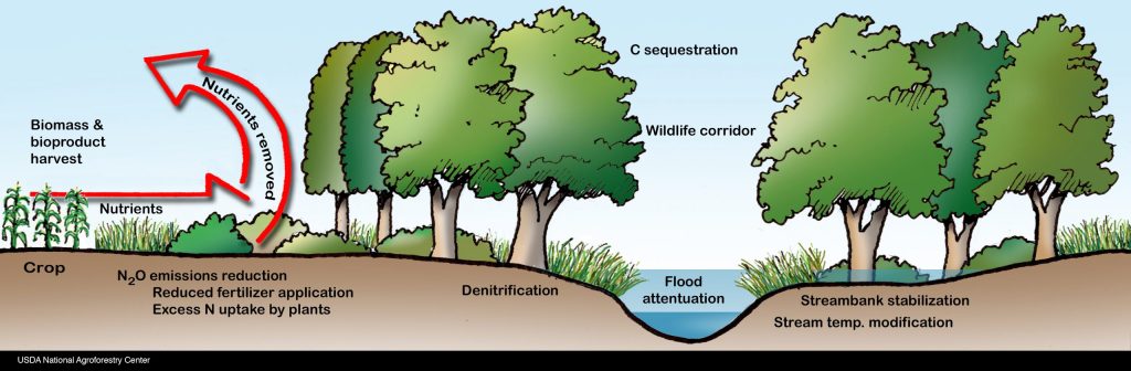
Riparian buffers sit at the intersection of land use and water quality. The word riparian refers to wetlands adjacent to rivers and streams. It’s called a buffer because it serves as a space between waterways and land uses that can harm them. So, a forested riparian buffer is basically an area next to water with a mix of trees, shrubs, and perennial plants managed specifically to protect water quality. This is accomplished by stabilizing eroding banks, maximizing rainfall infiltration, and minimizing rainfall runoff and sediments entering the waterway.
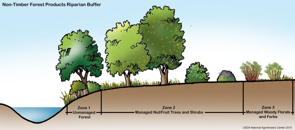
Forested riparian buffers are generally divided into three zones that run parallel to the water line.
- Zone one, the unmanaged forest, sits at the water’s edge where the goal is to stabilize the bank and improve aquatic habitat. In this sometimes-turbulent zone, it is important to have plants with different root structures and water tolerances to withstand seasonal variations in water level.
- Zone two, the managed forest, helps intercept polluted runoff and provides terrestrial wildlife habitat. It is also an ideal area for forest farming.
- Zone three is the transition zone between your riparian buffer and the land use you are buffering the waterway from (lawns, farm fields, roads, clear-cuts, etc.). This zone is insurance against big floods and a perfect area for pollinator habitat that includes perennial grasses and prairie species with deep fibrous roots that hold soil and promote rainfall infiltration.
Planning a riparian buffer and getting assistance
It’s a good idea to call your county forester before making a big investment to improve your riparian areas. With some planning, buffers can provide many benefits in addition to protecting water quality. You could include trees and shrubs with edibles, like apples, cherries, elderberries, currants, and hazelnuts. Zones two and three are also suitable for selective harvests of high-value timber crop trees, like black walnut and white oak. And no matter the other uses, forested riparian buffers are great for wildlife on land and in water. On the watershed scale, working with neighbors to link riparian buffers together as wildlife travel corridors is one of the most effective wildlife conservation strategies in landscapes squeezed by combines and condos.
Additional resources
- Riparian Forest Buffers overview (USDA)
- Riparian Forest Buffers: An Agroforestry Practice (USDA, 2017) (PDF)
- NRCS Riparian Forest Buffer – WI Guidance (USDA, 2021) (PDF)
- NRCS Riparian Forest Buffer – WI Practice Standard (USDA, 2013) (PDF)
- Conservation Buffers: Design Guidelines for Buffers, Corridors, and Greenways (USDA, 2008)
- Buffer$ – Conservation Buffer Economic Analysis Tool (USDA)
Explore all learning hub webpages
Woodland stewardship topics
Use a chainsaw safely & effectively
> Protective gear for safe chainsaw use
> Grow mushrooms using sawdust spawn
> Grow mushrooms using plug spawn
People and programs who provide assistance
If you have feedback on this webpage, fill out this form. If you have questions about riparian buffers, contact:

Tony Johnson
Forestry Outreach Specialist
anthony.johnson@wisc.edu
608-386-8900
Page written by Tony Johnson (UW–Madison Extension). Last updated March 2026.